Wind direction and speed affect dust and odor risk. The first step is to identify the prevailing downwind directions. Different wind speeds cause different challenges. High wind speed increases risk for dust, while low wind speeds and cooling conditions (typically, nighttime conditions) increase the risk of odor impacting neighbors.
Information on the prevalence of wind direction is available for many locations and may be illustrated as a ‘wind rose’. The visual presented in Figure 1 shows downwind direction – where dust and odorous air are most likely to go – using the same rose concepts; the longer the petal, the more often air will head in that direction (Figure 1). Frequencies are summarized for 21 Nebraska locations.
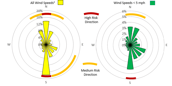
Downwind direction frequency can be used to evaluate sites for a new or expanding livestock facility – as dust and odor risk depend largely upon downwind direction frequency and separation distance. Note for some locations that higher-risk directions for dust (all wind speeds) may differ from those for odor (low speeds). Using these plots along with satellite images or plat maps can assist in initial screening of facility locations. Considering alternative sites along a line 90 degrees from the prevailing winds (East and West for Figure 1) can reveal preferred alternative building sites.